Contour Lines
Contour lines are used in mapping to represent the shape of the land. By interpreting them we get a three dimensional representation of what the terrain will look like. Each contour line connects different areas on the map that are at the same height above sea level. It is hard to overstate the importance of contours when navigating using a map. It is often said that they are the only thing that you can really rely on when reading a map. Walls deteriorate and become overgrown, footpaths move, tarns are sometimes dry.
Contours can be used as tick features, catchments and overshoots. Whenever you are looking for features to describe you leg on the map, include some contour features. For example, when walking along your handrail think what the shape of the land will look like. It may be fairly flat for a kilometre then a steep drop appears on the right followed by a ring contour to the left. Some people take to interpreting contour lines really easily, for most it takes a very long time. Expect to spend the next couple of years honing your skills.
Try printing off a contour only map and take that out to practice with. The OpenCycleMap.org website can generate one for you. This link shows part of the lake district as a contour only map
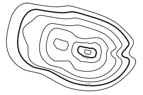
Take a look at the hill drawn above and try and answer the following questions
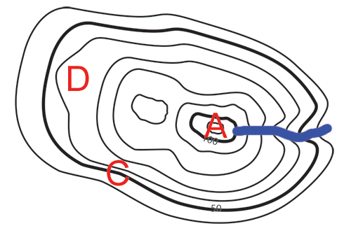
Identify the following points on the diagram.
A) The highest point
B) The place there is most likely to be a stream
C) The steepest point
D) The flattest point.
How high is the right hand peak?
Why are the numbered contours thicker?
Answers at the bottom of this page.
When looking at contours on the map they can be very confusing, especially what is up and what is down. Here are a few tips to tell the difference
1) If there are numbers on the contour lines then the bottom of the number is on the downhill side. Most text on maps is set so the top of the text is North and the bottom South but indications of height on contour lines show you what is up hill and what is down
2) If there is a stream marked and the contours kink like they do on the image above then the contour lines will appear to point up hill. This is because contour lines in valleys point up hill. You can probably either imagine this or observe it when out on a hill. You could even take a rope and lay it down crossing a stream trying to keep the rope at the same height above sea level.
The right hand peak is between 110 and 120 Meters high
The numbered contours are thicker and are called index contours they are thicker so you can count contours in 5's to make it easier.